
Free Part 107 practice · FAA 2021 samples

Read the airspace. Then check the permission.

These seven FAA sample questions focus on controlled airspace, military activity, NOTAMs and temporary restrictions. Use the chart to identify what is shown, then use the relevant rule to decide what the question requires. Answers and explanations are by Certbound.

Question 1 of 7FAA sample 2 · UA.I.B.K16
Regulations

According to 14 CFR part 107, how may a remote pilot operate an unmanned aircraft in Class C airspace?

Choose A, B or C
Only checked answers count toward the result.

0 / 7 checked

Untimed · answers stay in this page session. Checked answers remain fixed until you start again.

Three questions to keep separate

First identify the airspace or activity. Then check the altitude reference and the location in the question. Finally, determine which authorization or current-status source applies.

Those steps answer different things. An airport frequency is a communications detail. A chart boundary depicts an area. Neither, by itself, grants permission to operate a small unmanned aircraft.

The exercise uses questions 2, 8, 10, 13, 14, 30 and 46 from the FAA's 2021 sample set. Its result covers these seven items only. Use the full 46-question practice page to explore the rest of that sample set.

Prior authorization means before the operation

Under 14 CFR 107.41, a small UAS operation in Class B, C or D airspace, or within the lateral boundaries of an airport's designated Class E surface area, requires prior ATC authorization.

In sample question 2, Class C is stated directly. Monitoring a frequency or contacting ATC after launch does not meet the condition in that rule. The word prior decides the distinction.

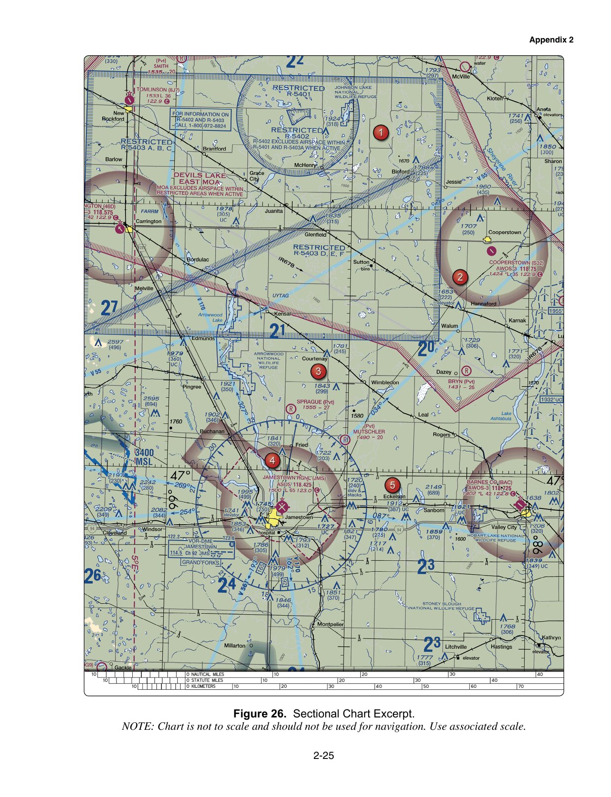
In question 13, the figure supplies the location instead. Find the stated position near Jamestown in the training excerpt, identify the charted surface airspace, then apply the authorization rule. Do not infer the answer merely from the presence or absence of a control-tower frequency.

For an actual operation, use the FAA's current airspace-authorization guidance. These practice images are not current operational charts, and the exercise does not request an authorization for you.

Read the sector and its units together

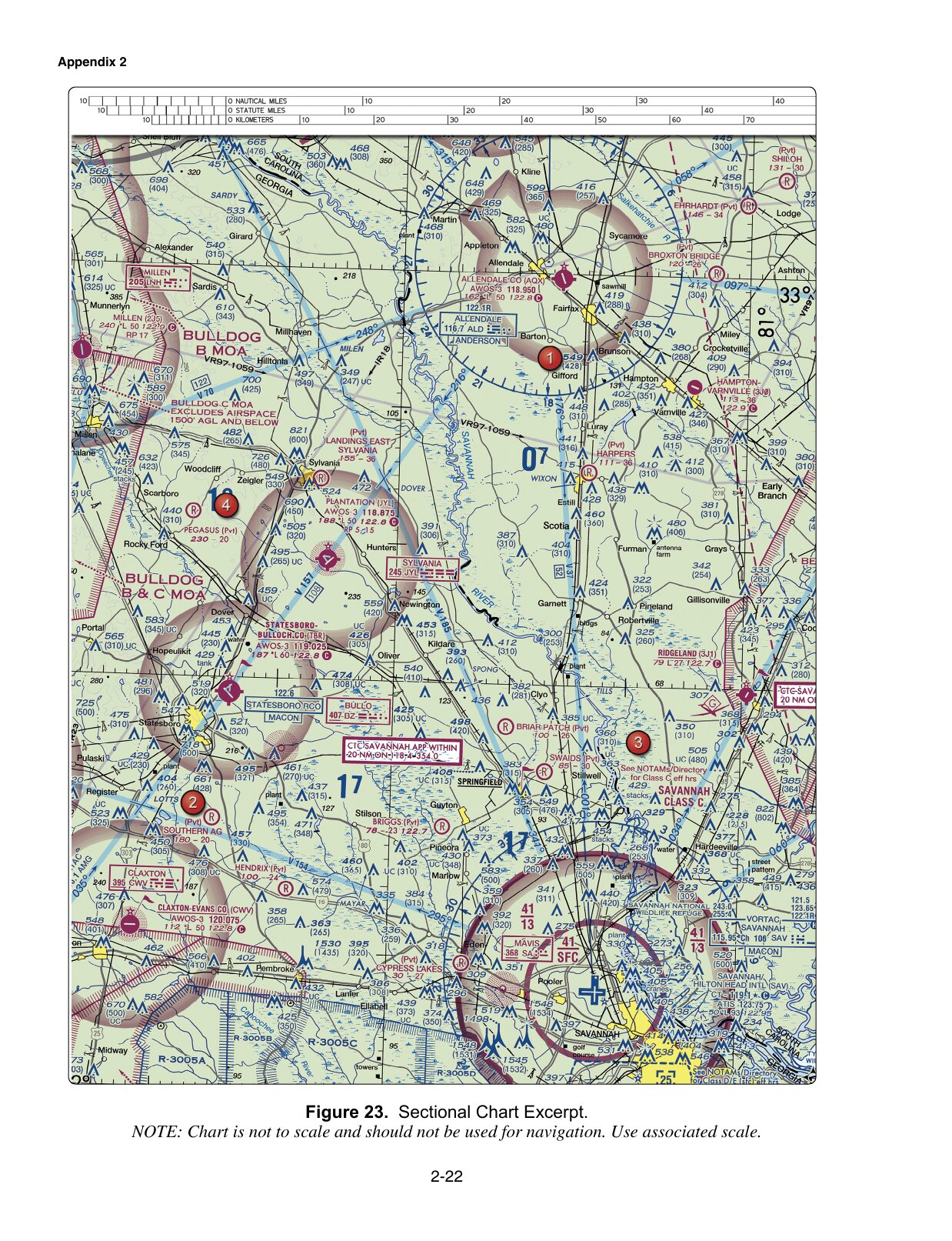
Question 8 asks about the floor of Savannah's Class C shelf in the supplied figure. Locate that shelf before reading its altitude label. In the relevant sector, the lower value is 13, representing 1,300 feet MSL.

The FAA Chart Users' Guide explains the Class C convention: ceiling and floor figures omit the last two zeros and use mean sea level. A number from another sector, or the same number described as AGL, does not answer the question asked.

MSL and AGL use different reference points. Do not substitute the familiar small-UAS height limit for a charted airspace floor. Read the stated unit every time.

A charted military area is not a live activity report

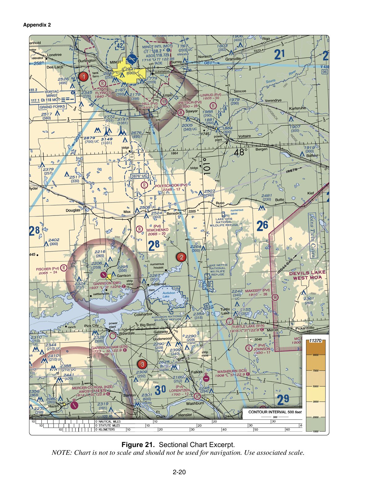
Question 10 points to a military operations area. The chart legend provides published hours, altitudes and a controlling agency, which explains the sample's selected answer. Actual activity can change; the AIM's special-use airspace guidance explains how to obtain current status.

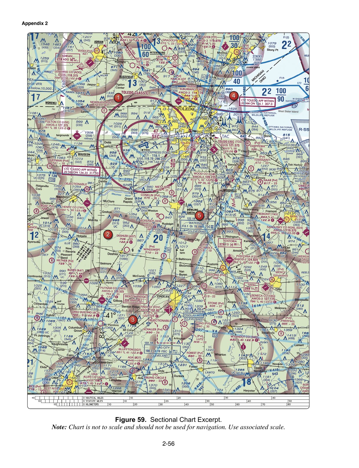
Question 30 asks about a military training route. Its four-digit identifiers indicate a route with no segment above 1,500 feet AGL. That designation does not prove that traffic stays above small-UAS operating heights, nor does it provide separation for your aircraft. See the AIM's MTR explanation.

MOA and MTR are different chart concepts. Learn what each label describes before trying to remember a single response to “military” in a question.

Read the restriction that applies today

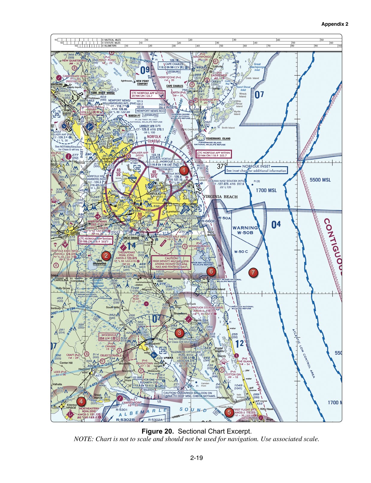
Question 14's balloon caution says to check NOTAMs. The sample's online-briefing option points to a current-information source. The old chart image shows why to look; it cannot tell you today's status of that hazard.

Question 46 concerns a sporting-event TFR. A sponsor relationship and a bystander notification do not create permission. 14 CFR 91.145(d) requires compliance with the published authorizations, terms and conditions, unless otherwise authorized through the stated routes. A general waiver is not a pass into every restricted event area.

When reviewing an answer, write the deciding condition beside it: prior authorization, the sector's MSL floor, current activity status, or the specific TFR's conditions. Those distinctions transfer to unfamiliar questions more usefully than a memorized option letter.

If the chart itself is the obstacle, continue with the sectional-chart reading practice. Certbound is not affiliated with the FAA; the published sample questions and Certbound's explanations are labeled separately throughout.
Question and source reference

Read any item without completing the exercise. FAA questions; answers and explanations by Certbound.

Regulations1 question
2. According to 14 CFR part 107, how may a remote pilot operate an unmanned aircraft in Class C airspace?

FAA sample · UA.I.B.K16

  • A. The remote pilot must have prior authorization from the Air Traffic Control (ATC) facility having jurisdiction over that airspace.
  • B. The remote pilot must monitor the Air Traffic Control (ATC) frequency from launch to recovery.
  • C. The remote pilot must contact the Air Traffic Control (ATC) facility after launching the unmanned aircraft.

Answer A, by Certbound. The rule conditions a Class C operation on prior authorization from ATC. Monitoring a frequency or calling after launch is not the authorization the rule requires.

Source excerpt

14 CFR Part 107 (eCFR 2025-11-03)
§ 107.41 Operation in certain airspace.Opens in a new tab

No person may operate a small unmanned aircraft in Class B, Class C, or Class D airspace or within the lateral boundaries of the surface area of Class E airspace designated for an airport unless that person has prior authorization from Air Traffic Control (ATC).

Practice sample 2
Airspace5 questions
8. (Refer to FAA-CT-8080-2H, Figure 23, area 3.) What is the floor of the Savannah Class C airspace at the shelf area (outer circle)?

FAA sample · UA.II.A.K1b

FAA F23
FAA training figure 23, referenced by sample question 8
FAA-CT-8080-2H · historical training excerpt. Open complete image (new tab)
  • A. 1,300 feet AGL.
  • B. 1,300 feet MSL.
  • C. 1,700 feet MSL.

Answer B, by Certbound. Charted Class C sector figures are MSL altitudes with the last two zeros dropped. The number below the bar in the shelf sector is its floor in feet MSL. Use the value in the sector named by the question, rather than an AGL reading or a value from a different sector.

Source excerpt

FAA Aeronautical Chart Users' Guide (2026-07)
FAA Chart Users Guide - VFR Terms and SymbolsOpens in a new tab

Class C Airspace is shown on Sectionals and TACs. The MSL ceiling and floor altitudes of each sector are shown in solid magenta figures with the last two zeros eliminated.

Practice sample 8
10. (Refer to FAA-CT-8080-2H, Figure 21.) You have been hired by a farmer to use your small UA to inspect his crops. The area that you are to survey is in the Devil's Lake West MOA, east of area 2. How would you find out if the MOA is active?

FAA sample · UA.II.A.K2

FAA F21
FAA training figure 21, referenced by sample question 10
FAA-CT-8080-2H · historical training excerpt. Open complete image (new tab)
  • A. Refer to the chart legend.
  • B. This information is available in the Small UAS database.
  • C. Refer to the Military Operations Directory.

Answer A, by Certbound. The sectional chart legend gives published MOA hours and the controlling agency, making A the best answer among these options. A printed schedule is not a live activity report. For an actual operation, check current status through Flight Service or the using or controlling agency.

Source excerpt

FAA AIM Chapter 3 Section 4
3-4-1 and 3-4-9 — published schedule and current status excerptsOpens in a new tab

Permanent SUA (except CFAs) is charted on Sectional Aeronautical, VFR Terminal Area, and applicable En Route charts, and include the hours of operation, altitudes, and the controlling agency. Pilots can request the status of SUA by contacting the using or controlling agency. The frequency for the controlling agency is tabulated in the margins of the applicable IFR and VFR charts.

Practice sample 10
14. (Refer to FAA-CT-8080-2H, Figure 20, area 5.) How would a remote PIC "CHECK NOTAMS" as noted in the CAUTION box regarding the unmarked balloon?

FAA sample · UA.II.B.K5

FAA F20
FAA training figure 20, referenced by sample question 14
FAA-CT-8080-2H · historical training excerpt. Open complete image (new tab)
  • A. By utilizing the B4UFLY mobile application.
  • B. By contacting the FAA district office.
  • C. By obtaining a briefing via an online source such as: 1800WXBrief.com.

Answer C, by Certbound. The advisory circular points remote pilots to the Flight Service website for NOTAMs and briefings, which is what the caution box asks the pilot to check. B4UFLY is an airspace awareness app and a district office is not the NOTAM source.

Source excerpt

FAA AC 107-2A Small UAS
2.2 Notices to Airmen (NOTAM). Information on how to obtain NOTAMs can be found Opens in a new tab

2.2.1 Additional resources to create NOTAMs, check weather, and prepare flight plans can be found at https://www.1800wxbrief.com/.

Practice sample 14
30. (Refer to FAA-CT-8080-2H, Figure 59, area 2.) The chart shows a gray line with "VR1667, VR1617, VR1638, and VR1668." Could this area present a hazard to the operations of a small UA?

FAA sample · UA.II.A.K2

FAA F59
FAA training figure 59, referenced by sample question 30
FAA-CT-8080-2H · historical training excerpt. Open complete image (new tab)
  • A. No, all operations will be above 400 feet.
  • B. Yes, this is a Military Training Route from the surface to 1,500 feet AGL.
  • C. Yes, the defined route provides traffic separation to manned aircraft.

Answer B, by Certbound. Each charted route on that line carries four digits, which marks a military training route with no segment above 1,500 feet AGL. Military traffic can therefore be expected down through the altitudes a small UA uses, so the area is a hazard.

Source excerpt

FAA AIM Chapter 3 Section 5 Airspace
3-5-2. Military Training RoutesOpens in a new tab

MTRs with no segment above 1,500 feet AGL must be identified by four number characters; e.g., IR1206, VR1207.

Practice sample 30
46. Your surveying company is a title sponsor for a race team at the Indianapolis 500. To promote your new aerial surveying department, you decide to video part of the race using a small UA. The FAA has issued a Temporary Flight Restriction (TFR) for the race in the area you plan to fly. In this situation

FAA sample · UA.II.A.K3

  • A. you may fly your drone in the TFR since your company is sponsoring a team at the race.
  • B. the TFR applies to all aircraft; you may not fly in the area without a Certificate of Waiver or Authorization.
  • C. flying your drone is allowed if you notify all non-participating people of the closed course UA operation.

Answer B, by Certbound. Sponsoring a race team or notifying bystanders does not authorize the flight. The operation must comply with the TFR’s published authorizations, terms and conditions, unless otherwise authorized by ATC or an event-specific Flight Standards Certificate of Waiver or Authorization. A general waiver is not permission to enter any TFR.

Source excerpt

14 CFR Part 91 (eCFR, current text checked 2026-09-09)
§ 91.145(d) — event TFR authorizationsOpens in a new tab

(d) When a NOTAM has been issued in accordance with this section, no person may operate an aircraft or device, or engage in any activity within the designated airspace area, except in accordance with the authorizations, terms, and conditions of the temporary flight restriction published in the NOTAM, unless otherwise authorized by: (1) Air traffic control; or (2) A Flight Standards Certificate of Waiver or Authorization issued for the demonstration or event.

Practice sample 46
Operations1 question
13. (Refer to FAA-CT-8080-2H, Figure 26, area 4.) You have been hired to inspect the tower under construction at 46.9N and 98.6W, near Jamestown Regional (JMS). What must you receive prior to flying your unmanned aircraft in this area?

FAA sample · UA.V.B.K6a

FAA F26
FAA training figure 26, referenced by sample question 13
FAA-CT-8080-2H · historical training excerpt. Open complete image (new tab)
  • A. Authorization from the military.
  • B. Authorization from ATC.
  • C. Authorization from the National Park Service.

Answer B, by Certbound. The tower under construction plots inside the dashed magenta boundary of the Class E surface area charted for Jamestown Regional, which is controlled airspace under this rule. Operating there requires prior ATC authorization; neither the military nor the National Park Service controls that airspace.

Source excerpt

14 CFR Part 107 (eCFR 2025-11-03)
§ 107.41 Operation in certain airspace.Opens in a new tab

No person may operate a small unmanned aircraft in Class B, Class C, or Class D airspace or within the lateral boundaries of the surface area of Class E airspace designated for an airport unless that person has prior authorization from Air Traffic Control (ATC).

Practice sample 13