
Free Part 107 practice · FAA 2021 samples

Find the label that decides the answer.

These ten questions use sectional-chart excerpts from the FAA's published sample set. Open the referenced figure, locate the place named in the question, and read the symbol with its units. Certbound supplies the answers, explanations and reading notes.

Question 1 of 10FAA sample 5 · UA.V.B.K6a
Operations

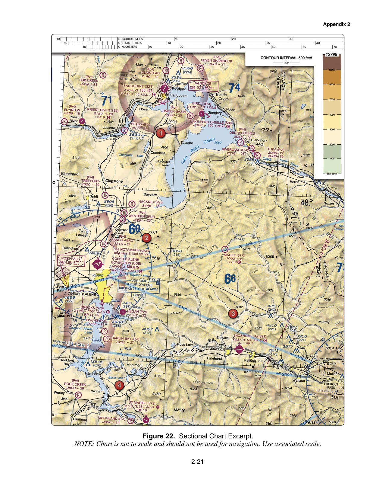
(Refer to FAA-CT-8080-2H, Figure 22, area 2.) At Coeur D'Alene which frequency should be used as a Common Traffic Advisory Frequency (CTAF) to monitor airport traffic?

FAA F22
FAA training figure 22, referenced by sample question 5
FAA-CT-8080-2H · historical training excerpt. Open complete image (new tab)
Choose A, B or C
Only checked answers count toward the result.

0 / 10 checked

Untimed · answers stay in this page session. Checked answers remain fixed until you start again.

Use the whole figure before enlarging a detail

Check the figure number and the numbered area first. Then find the airport, sector, route or caution box named in the question. Enlarge figure lets you inspect the original image more closely; use the scroll area to move around it and Fit figure to restore the overview.

Keep nearby boundaries and labels in view. A number can be perfectly legible and still belong to a different airport or sector. Each question also links to its complete figure so the surrounding context remains available.

The images are FAA-CT-8080-2H training excerpts used by the 2021 samples. They are not current navigation products. A display zoom changes the size on your screen, not the chart's scale or the underlying data.

Three examples of a useful reading sequence

SampleFindReadAvoid substituting
5 · Figure 22Coeur D'Alene airport data block122.8 with the circled C marking CTAFThe AWOS frequency or a separate communications box
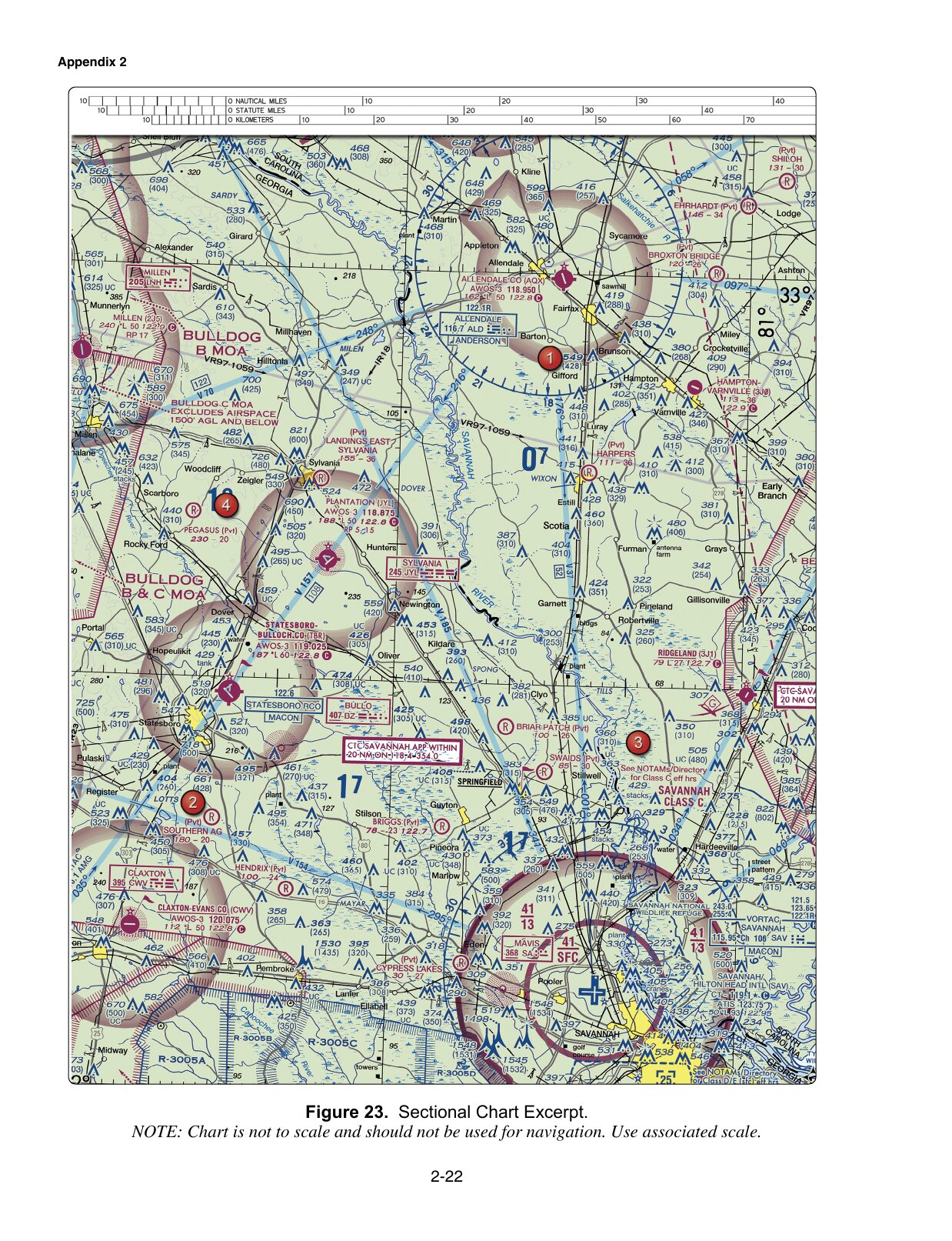
8 · Figure 23The Class C shelf sector named in the questionFloor 13 → 1,300 feet MSLAnother sector's value or an AGL label
9 · Figure 20The balloon caution near the stated positionCable to 3,008 feet MSL; check NOTAMsAGL or a caution belonging to another location

Those readings answer these training questions. They do not establish today's frequency, airspace boundary or balloon status at the named locations.

Use the FAA Chart Users' Guide to check an unfamiliar symbol. In question 5, the communications symbol distinguishes CTAF from other nearby frequencies. In question 8, the sector location and altitude reference matter together. In question 9, the caution's own wording supplies the hazard and its vertical reference.

Keep position, direction and distance separate

Question 24 gives latitude and longitude. Use the printed graticule and the named airports to locate the approximate position. Question 31 asks what latitude measures: north or south of the equator. The fact that a parallel runs across the page does not turn latitude into an east–west coordinate.

Question 18 requires a traffic-pattern interpretation. A downwind leg is parallel to the runway and opposite the landing direction. Combine that with the stated left pattern and runway orientation. Locating the runway number is not the whole reasoning step; the AIM's airport-operations section defines the pattern terms.

Do not measure a distance with a ruler against the physical size of a resized screenshot. The excerpts warn that they are not to scale and direct the reader to the associated scale. This practice does not ask you to manufacture a distance from a blurry or missing mark.

Know when the image is only the starting point

A military-area label, route number or NOTAM caution points to a further check. Questions 10 and 14 ask where to obtain information; question 13 requires a rule as well as the location. The supplied image cannot establish real-time activity or grant authorization.

Use airspace practice to work through those distinctions. Read the explanation and source together, especially when an answer depends on prior authorization or a current restriction.

Prepare for unfamiliar images

FAA's June 2026 testing advisory says the UAG will include image-based questions not found in the testing supplements beginning October 27, 2026. It also says that the date for removing supplements from test centers has not been set.

Use these published figures to learn a repeatable process: identify the requested location, read the relevant label, retain its units and apply the appropriate rule. Do not treat a memorized pairing such as “Figure 22 means C” as preparation for a different image.

The ten items here are a selected part of the full 46-question FAA sample practice. A result on them measures this attempt, not all chart-reading ability or readiness for certification. The FAA supplied the sample questions; the answer key and explanations on this site are Certbound's. Certbound is not affiliated with the FAA.
Question and source reference

Read any item without completing the exercise. FAA questions; answers and explanations by Certbound.

Airspace4 questions
8. (Refer to FAA-CT-8080-2H, Figure 23, area 3.) What is the floor of the Savannah Class C airspace at the shelf area (outer circle)?

FAA sample · UA.II.A.K1b

FAA F23
FAA training figure 23, referenced by sample question 8
FAA-CT-8080-2H · historical training excerpt. Open complete image (new tab)
  • A. 1,300 feet AGL.
  • B. 1,300 feet MSL.
  • C. 1,700 feet MSL.

Answer B, by Certbound. Charted Class C sector figures are MSL altitudes with the last two zeros dropped. The number below the bar in the shelf sector is its floor in feet MSL. Use the value in the sector named by the question, rather than an AGL reading or a value from a different sector.

Source excerpt

FAA Aeronautical Chart Users' Guide (2026-07)
FAA Chart Users Guide - VFR Terms and SymbolsOpens in a new tab

Class C Airspace is shown on Sectionals and TACs. The MSL ceiling and floor altitudes of each sector are shown in solid magenta figures with the last two zeros eliminated.

Practice sample 8
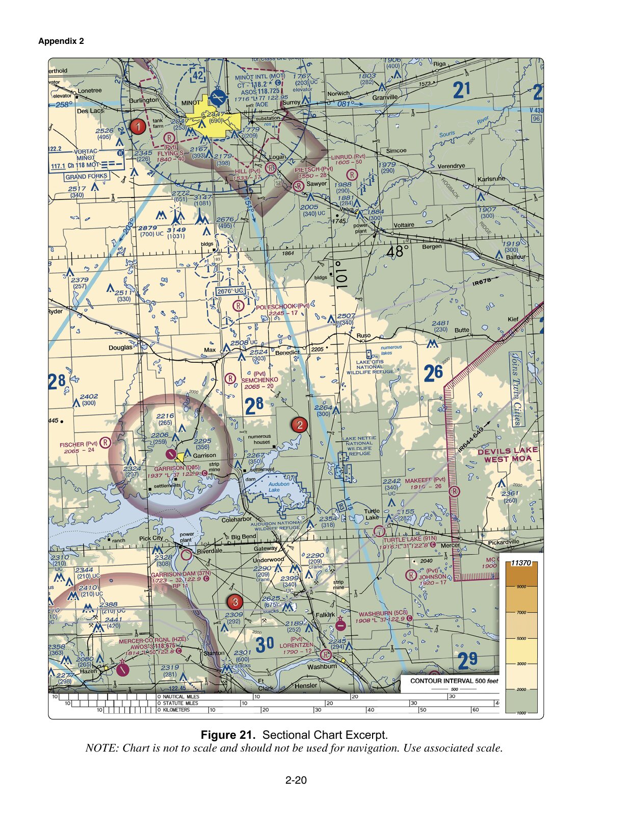
10. (Refer to FAA-CT-8080-2H, Figure 21.) You have been hired by a farmer to use your small UA to inspect his crops. The area that you are to survey is in the Devil's Lake West MOA, east of area 2. How would you find out if the MOA is active?

FAA sample · UA.II.A.K2

FAA F21
FAA training figure 21, referenced by sample question 10
FAA-CT-8080-2H · historical training excerpt. Open complete image (new tab)
  • A. Refer to the chart legend.
  • B. This information is available in the Small UAS database.
  • C. Refer to the Military Operations Directory.

Answer A, by Certbound. The sectional chart legend gives published MOA hours and the controlling agency, making A the best answer among these options. A printed schedule is not a live activity report. For an actual operation, check current status through Flight Service or the using or controlling agency.

Source excerpt

FAA AIM Chapter 3 Section 4
3-4-1 and 3-4-9 — published schedule and current status excerptsOpens in a new tab

Permanent SUA (except CFAs) is charted on Sectional Aeronautical, VFR Terminal Area, and applicable En Route charts, and include the hours of operation, altitudes, and the controlling agency. Pilots can request the status of SUA by contacting the using or controlling agency. The frequency for the controlling agency is tabulated in the margins of the applicable IFR and VFR charts.

Practice sample 10
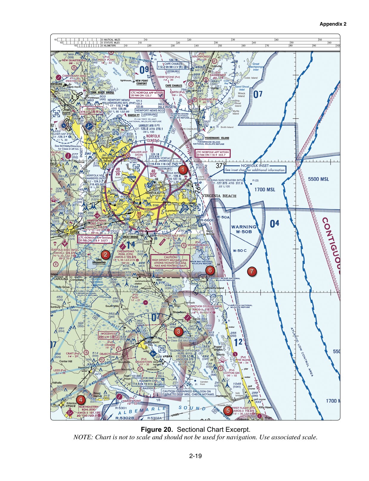
14. (Refer to FAA-CT-8080-2H, Figure 20, area 5.) How would a remote PIC "CHECK NOTAMS" as noted in the CAUTION box regarding the unmarked balloon?

FAA sample · UA.II.B.K5

FAA F20
FAA training figure 20, referenced by sample question 14
FAA-CT-8080-2H · historical training excerpt. Open complete image (new tab)
  • A. By utilizing the B4UFLY mobile application.
  • B. By contacting the FAA district office.
  • C. By obtaining a briefing via an online source such as: 1800WXBrief.com.

Answer C, by Certbound. The advisory circular points remote pilots to the Flight Service website for NOTAMs and briefings, which is what the caution box asks the pilot to check. B4UFLY is an airspace awareness app and a district office is not the NOTAM source.

Source excerpt

FAA AC 107-2A Small UAS
2.2 Notices to Airmen (NOTAM). Information on how to obtain NOTAMs can be found Opens in a new tab

2.2.1 Additional resources to create NOTAMs, check weather, and prepare flight plans can be found at https://www.1800wxbrief.com/.

Practice sample 14
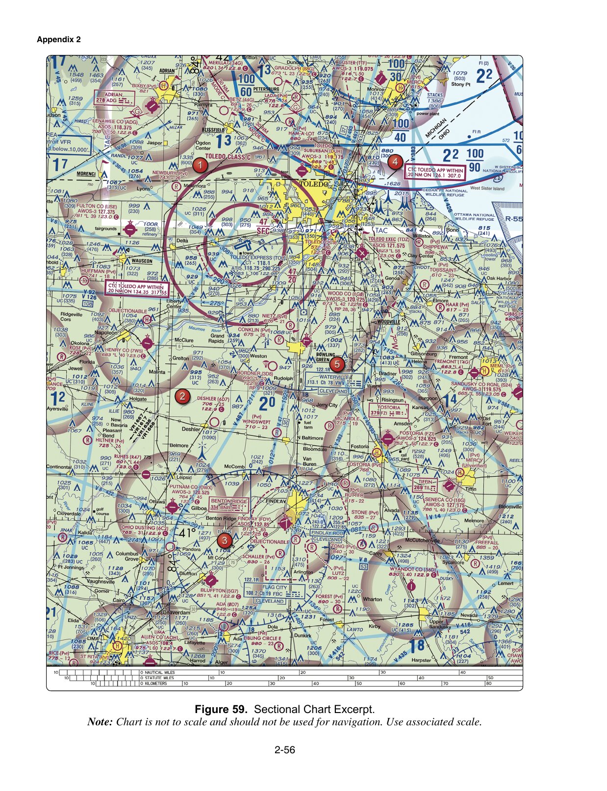
30. (Refer to FAA-CT-8080-2H, Figure 59, area 2.) The chart shows a gray line with "VR1667, VR1617, VR1638, and VR1668." Could this area present a hazard to the operations of a small UA?

FAA sample · UA.II.A.K2

FAA F59
FAA training figure 59, referenced by sample question 30
FAA-CT-8080-2H · historical training excerpt. Open complete image (new tab)
  • A. No, all operations will be above 400 feet.
  • B. Yes, this is a Military Training Route from the surface to 1,500 feet AGL.
  • C. Yes, the defined route provides traffic separation to manned aircraft.

Answer B, by Certbound. Each charted route on that line carries four digits, which marks a military training route with no segment above 1,500 feet AGL. Military traffic can therefore be expected down through the altitudes a small UA uses, so the area is a hazard.

Source excerpt

FAA AIM Chapter 3 Section 5 Airspace
3-5-2. Military Training RoutesOpens in a new tab

MTRs with no segment above 1,500 feet AGL must be identified by four number characters; e.g., IR1206, VR1207.

Practice sample 30
Operations6 questions
5. (Refer to FAA-CT-8080-2H, Figure 22, area 2.) At Coeur D'Alene which frequency should be used as a Common Traffic Advisory Frequency (CTAF) to monitor airport traffic?

FAA sample · UA.V.B.K6a

FAA F22
FAA training figure 22, referenced by sample question 5
FAA-CT-8080-2H · historical training excerpt. Open complete image (new tab)
  • A. 122.05 MHz.
  • B. 135.075 MHz.
  • C. 122.8 MHz.

Answer C, by Certbound. In an airport data block the circled C marks the CTAF, and on this block it follows 122.8. The other two frequencies are the automated weather broadcast and a separate boxed communications outlet.

Chart reading by Certbound

FAA-CT-8080-2H Airman Knowledge Testing Supplement (figures)
Figure 22. Sectional Chart Excerpt. Coeur D’Alene-Boyington (COE), area 2.Opens in a new tab

Airport data block next to the area 2 marker: "COEUR D'ALENE-BOYINGTON (COE) / AWOS-3 135.075 / 2320 *L 74 122.8" with 122.8 followed by the solid magenta circled C symbol, then "RP 2".

Practice sample 5
9. (Refer to FAA-CT-8080-2H, Figure 20, area 3.) With ATC authorization, you are operating your small unmanned aircraft approximately 4 SM southeast of Elizabeth City Regional Airport (ECG). What hazard is indicated to be in that area?

FAA sample · UA.V.B.K6a

FAA F20
FAA training figure 20, referenced by sample question 9
FAA-CT-8080-2H · historical training excerpt. Open complete image (new tab)
  • A. High density military operations in the vicinity.
  • B. Unmarked balloon on a cable up to 3,008 feet AGL.
  • C. Unmarked balloon on a cable up to 3,008 feet MSL.

Answer C, by Certbound. The charted caution box in that area names an unmarked balloon on a cable and gives its top as an MSL altitude. The option that reads the same figure as AGL misstates the reference, and no high-density military note is charted there.

Practice sample 9
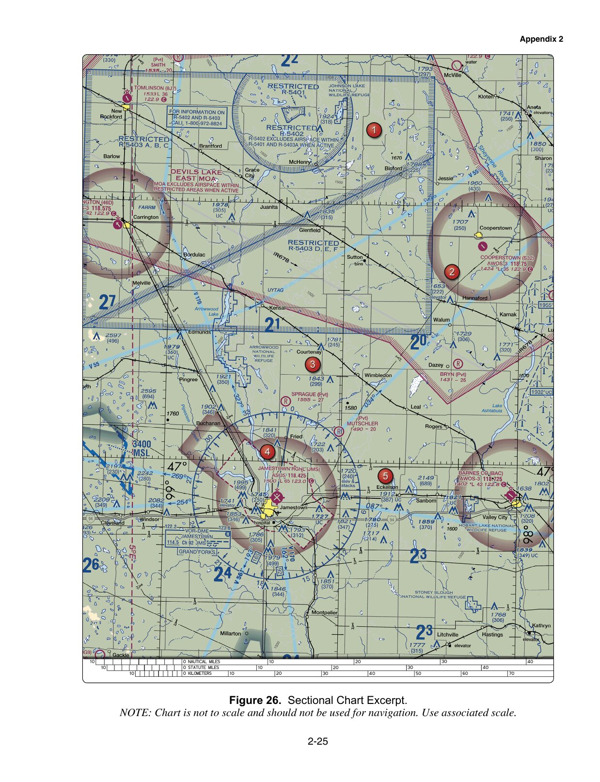
13. (Refer to FAA-CT-8080-2H, Figure 26, area 4.) You have been hired to inspect the tower under construction at 46.9N and 98.6W, near Jamestown Regional (JMS). What must you receive prior to flying your unmanned aircraft in this area?

FAA sample · UA.V.B.K6a

FAA F26
FAA training figure 26, referenced by sample question 13
FAA-CT-8080-2H · historical training excerpt. Open complete image (new tab)
  • A. Authorization from the military.
  • B. Authorization from ATC.
  • C. Authorization from the National Park Service.

Answer B, by Certbound. The tower under construction plots inside the dashed magenta boundary of the Class E surface area charted for Jamestown Regional, which is controlled airspace under this rule. Operating there requires prior ATC authorization; neither the military nor the National Park Service controls that airspace.

Source excerpt

14 CFR Part 107 (eCFR 2025-11-03)
§ 107.41 Operation in certain airspace.Opens in a new tab

No person may operate a small unmanned aircraft in Class B, Class C, or Class D airspace or within the lateral boundaries of the surface area of Class E airspace designated for an airport unless that person has prior authorization from Air Traffic Control (ATC).

Practice sample 13
18. (Refer to FAA-CT-8080-2H, Figure 26, area 2.) While monitoring the Cooperstown CTAF you hear an aircraft announce that they are midfield left downwind to RWY 13. Where would the aircraft be relative to the runway?

FAA sample · UA.V.A.K3

FAA F26
FAA training figure 26, referenced by sample question 18
FAA-CT-8080-2H · historical training excerpt. Open complete image (new tab)
  • A. The aircraft is East.
  • B. The aircraft is South.
  • C. The aircraft is West.

Answer A, by Certbound. The runway number gives the runway's azimuth, so its downwind leg is flown on the reciprocal heading. With left traffic the runway sits off the left wing, which puts an aircraft on that downwind on the east side of the runway.

Source excerpt

FAA AIM Chapter 4 Section 3
4-3-2 and 4-3-6 — downwind and runway-number excerptsOpens in a new tab

Downwind leg. A flight path parallel to the landing runway in the opposite direction of landing. Runways are identified by numbers that indicate the nearest 10-degree increment of the azimuth of the runway centerline.

Practice sample 18
24. (Refer to FAA-CT-8080-2H, Figure 21.) What airport is located approximately 47 (degrees) 40 (minutes) N latitude and 101 (degrees) 26 (minutes) W longitude?

FAA sample · UA.V.B.K6a

FAA F21
FAA training figure 21, referenced by sample question 24
FAA-CT-8080-2H · historical training excerpt. Open complete image (new tab)
  • A. Mercer County Regional Airport.
  • B. Semshenko Airport.
  • C. Garrison Airport.

Answer C, by Certbound. Measured against the charted parallel and meridian on this excerpt, the given coordinates fall on Garrison. Mercer County Regional plots much further south and Semchenko lies north-east and closer to the meridian.

Chart reading by Certbound

FAA-CT-8080-2H Airman Knowledge Testing Supplement (figures)
Figure 21. Sectional Chart Excerpt. Garrison (D05) and the charted 48-degree parallel / 101-degree meridian.Opens in a new tab

Garrison plots roughly 20 minutes south of the 48-degree parallel and roughly 26 minutes west of the 101-degree meridian.

Practice sample 24
31. (Refer to FAA-CT-8080-2H, Figure 26.) What does the line of latitude at area 4 measure?

FAA sample · UA.V.B.K6a

FAA F26
FAA training figure 26, referenced by sample question 31
FAA-CT-8080-2H · historical training excerpt. Open complete image (new tab)
  • A. The degrees of latitude east and west of the Prime Meridian.
  • B. The degrees of latitude north and south of the equator.
  • C. The degrees of latitude east and west of the line that passes through Greenwich, England.

Answer B, by Certbound. The line through that area runs east and west and is labeled in degrees at both borders, which makes it a parallel of latitude. Latitude is counted north and south of the equator; the two rejected options describe an east-west measurement, which is longitude.

Chart reading by Certbound

FAA-CT-8080-2H Airman Knowledge Testing Supplement (figures)
Figure 26. Sectional Chart Excerpt. The parallel of latitude passing through area 4.Opens in a new tab

A horizontal ticked line runs east-west across the excerpt through the area 4 marker and is labeled "47 degrees" at both the left and the right chart border.

Practice sample 31