 Certbound
Where is the legend?
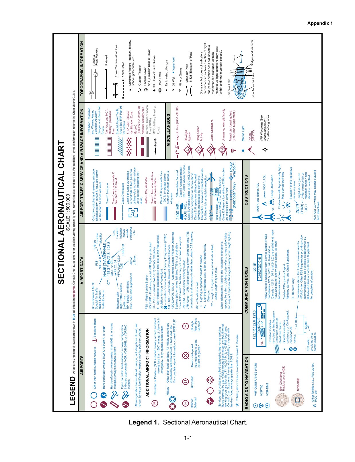 Open the complete FAA legend to zoom (new tab)
The image is Legend 1 from FAA-CT-8080-2H, page 1-1. The complete historical page is preserved, including its sideways layout. Open the full image to zoom into a label. It is public-domain FAA material, not current airport information.
For current symbol conventions, use the FAA's Aeronautical Chart Users' Guide. The July 9, 2026 edition's VFR sections explain airports, airspace, terrain and obstacles. Check the edition and effective date of the chart you are reading.
Which lines show controlled airspace?
The FAA Chart Users' Guide, pages 16–17 and 26–28, distinguishes these depictions:
| Mark | Read it as | Check next |
|---|---|---|
| Solid blue boundary | Class B airspace | The floor and ceiling of the specific sector |
| Solid magenta boundary | Class C airspace | The sector's floor and ceiling, not just distance from the airport |
| Dashed blue boundary | Class D airspace | The boxed ceiling and any operating-hours note |
| Dashed magenta boundary | Class E surface area | The boundary at the proposed operation |
| Faded magenta edge | Class E floor of 700 feet AGL | Which side of the vignette contains the operation |
A magenta airport symbol is not itself Class C airspace. A dashed magenta surface boundary is different from a faded magenta edge. Read the line, not color alone. The legend identifies airspace; the rules determine what your operation requires. Review 14 CFR 107.41 and the airspace questions.
Are the altitudes MSL or AGL?
MSL means mean sea level. AGL means above ground level. The reference changes the answer even when both numbers are in feet.
Class B and C sector labels omit the last two zeros. A label of 100/40 means a ceiling of 10,000 feet MSL and a floor of 4,000 feet MSL. SFC means surface. A Class D ceiling label of [-25] means up to, but not including, 2,500 feet MSL. These examples apply the notation in the FAA guide, page 16; they are not a named airport's current airspace.
The 700-foot Class E vignette uses AGL. Do not convert that into a 700-foot MSL floor. Use the label and legend together, then work through the sectional-chart questions.
What is a maximum elevation figure?
A maximum elevation figure (MEF) summarizes the highest elevation in a chart quadrant, including terrain and vertical obstacles, with allowances described by the FAA. The large digit gives thousands of feet; the smaller digit gives hundreds. A large 3 with a small 2 reads as 3,200 feet MSL.
It is not the terrain elevation at your aircraft, a controlled-airspace ceiling or permission to fly at that altitude. The calculation includes error allowances and rounding; see the FAA guide, pages 12–13. Do not subtract the MEF from an airspace ceiling to claim exact clearance over a particular point.
How do you read an obstacle label?
The legend separates obstacles below 1,000 feet AGL from those at or above 1,000 feet AGL, and marks lighted obstacles. The upper number is the top's elevation in feet MSL; the number in parentheses is its height AGL. In the historical legend, 2049 (1149) means a top at 2,049 feet MSL and a height of 1,149 feet above the ground.
Look for group symbols and high-intensity lighting marks too. Small chart symbols cannot show every hazard. The FAA guide, pages 10–13, explains obstacle depiction and limitations.
What do the airport symbols and labels tell you?
Blue airport symbols generally identify airports with control towers; magenta identifies others. The symbol also distinguishes runway types. An airport's nearby data can include its elevation, runway length, lighting, CTAF and services. The meaning comes from the specific annotation, not the order you remember from another airport.
For example, runway lengths may be shown in hundreds of feet, while airport elevation is in feet MSL. A runway-length number is not an airspace floor. Read the airport-data key in the legend and the FAA guide, pages 14–16 and 23–24. Historical frequencies in a training figure are not a current communications reference.
How can you check your reading?
Choose a sectional sample question. Before opening the answer, name the decisive symbol, its number and its unit. If your explanation is only a remembered letter, try another figure.
The October 26 exam change adds images outside the supplement. Use unfamiliar charts to test the reading method. For other subjects, follow the Part 107 study guide. Sources checked October 17, 2026.